|
|
|||||
| |

|
|
||||||||||||||||||||||||||||||||||||||||||||||||||||||||||||||||||||||||
| vector based GIS | ||||||||||||||||||||||||||||||||||||||||||||||||||||||||||||||||||||||||
| general definitions | ||||||||||||||||||||||||||||||||||||||||||||||||||||||||||||||||||||||||
| vector representations of data | ||||||||||||||||||||||||||||||||||||||||||||||||||||||||||||||||||||||||
| vector models | ||||||||||||||||||||||||||||||||||||||||||||||||||||||||||||||||||||||||
| advantages/disadvantages of raster and vector data models | ||||||||||||||||||||||||||||||||||||||||||||||||||||||||||||||||||||||||
| data bases | ||||||||||||||||||||||||||||||||||||||||||||||||||||||||||||||||||||||||
| data entry | ||||||||||||||||||||||||||||||||||||||||||||||||||||||||||||||||||||||||
|
|
||||||||||||||||||||||||||||||||||||||||||||||||||||||||||||||||||||||||
|
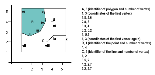
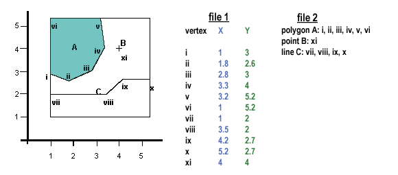
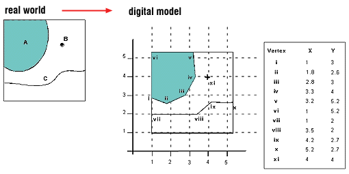
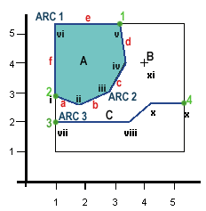
Vector is a data structure, used to store spatial data. Vector data is comprised of lines or arcs, defined by beginning and end points, which meet at nodes. The locations of these nodes and the topological structure are usually stored explicitly. Features are defined by their boundaries only and curved lines are represented as a series of connecting arcs. Vector storage involves the storage of explicit topology, which raises overheads, however it only stores those points which define a feature and all space outside these features is 'non-existent'. A vector based GIS is defined by the vectorial representation of its geographic data. According with the characteristics of this data model, geographic objects are explicitly represented and, within the spatial characteristics, the thematic aspects are associated. There are different ways of organising this double
data base (spatial and thematic). Usually, vectorial systems are composed
of two components: the one that manages spatial data and the one that
manages thematic data. This is the named hybrid organisation system,
as it links a relational data base for the attributes with a topological
one for the spatial data. A key element in these kind of systems is
the identifier of every object. This identifier is unique and
different for each object and allows the system to connect both data
bases. |
||||||||||||||||||||||||||||||||||||||||||||||||||||||||||||||||||||||||
|
|
||||||||||||||||||||||||||||||||||||||||||||||||||||||||||||||||||||||||
|
||||||||||||||||||||||||||||||||||||||||||||||||||||||||||||||||||||||||
|
|
||||||||||||||||||||||||||||||||||||||||||||||||||||||||||||||||||||||||
|
|
||||||||||||||||||||||||||||||||||||||||||||||||||||||||||||||||||||||||
|
|
||||||||||||||||||||||||||||||||||||||||||||||||||||||||||||||||||||||||
| Vector
representation of data In the vector based model (figure 4), geospatial data is represented in the form of co-ordinates. In vector data, the basic units of spatial information are points, lines (arcs) and polygons. Each of these units is composed simply as a series of one or more co-ordinate points, for example, a line is a collection of related points, and a polygon is a collection of related lines. |
||||||||||||||||||||||||||||||||||||||||||||||||||||||||||||||||||||||||
| co-ordinate
|
||||||||||||||||||||||||||||||||||||||||||||||||||||||||||||||||||||||||
| point
|
||||||||||||||||||||||||||||||||||||||||||||||||||||||||||||||||||||||||
| line
|
||||||||||||||||||||||||||||||||||||||||||||||||||||||||||||||||||||||||
| arc
|
||||||||||||||||||||||||||||||||||||||||||||||||||||||||||||||||||||||||
| polygon
|
||||||||||||||||||||||||||||||||||||||||||||||||||||||||||||||||||||||||
|
|
||||||||||||||||||||||||||||||||||||||||||||||||||||||||||||||||||||||||
|
vector
models |
||||||||||||||||||||||||||||||||||||||||||||||||||||||||||||||||||||||||
|
|
||||||||||||||||||||||||||||||||||||||||||||||||||||||||||||||||||||||||
|
|
||||||||||||||||||||||||||||||||||||||||||||||||||||||||||||||||||||||||
|
|
||||||||||||||||||||||||||||||||||||||||||||||||||||||||||||||||||||||||
|
|
||||||||||||||||||||||||||||||||||||||||||||||||||||||||||||||||||||||||
|
|
||||||||||||||||||||||||||||||||||||||||||||||||||||||||||||||||||||||||
 |
||||||||||||||||||||||||||||||||||||||||||||||||||||||||||||||||||||||||
|
||||||||||||||||||||||||||||||||||||||||||||||||||||||||||||||||||||||||
| see the Vector Overlay module for information on vector based GIS overlay operations | ||||||||||||||||||||||||||||||||||||||||||||||||||||||||||||||||||||||||
|
|
||||||||||||||||||||||||||||||||||||||||||||||||||||||||||||||||||||||||
|
|
||||||||||||||||||||||||||||||||||||||||||||||||||||||||||||||||||||||||
| advantages/disadvantages of raster and vector data models | ||||||||||||||||||||||||||||||||||||||||||||||||||||||||||||||||||||||||
|
||||||||||||||||||||||||||||||||||||||||||||||||||||||||||||||||||||||||
|
|
||||||||||||||||||||||||||||||||||||||||||||||||||||||||||||||||||||||||
| data bases | ||||||||||||||||||||||||||||||||||||||||||||||||||||||||||||||||||||||||
|
The elements in a vector based GIS are then the DBMS (Data Base Management System) for the attributes and the system that manages the topological data. In some GIS packages, the DBMS is based in an existing software, i.e. dBASE. |
||||||||||||||||||||||||||||||||||||||||||||||||||||||||||||||||||||||||
entity-relation model Three elements are considered in this approach: (a) Entities as the relevant objects for the data base. In a GIS, an entity is any fact that can be localised spatially. (b) Attributes or characteristics attached to the entities. Each attribute has a limited domain of possible values, i.e. the quality of a road can be bad, average, good, very good. (c) Relations or mechanisms that allow to relate entities. Some examples are: ‘located in’, ‘contained in’, ‘crossed with’, etc. |
||||||||||||||||||||||||||||||||||||||||||||||||||||||||||||||||||||||||
DBMS The data bases used in GIS are most commonly relational. Nevertheless, Object Oriented data bases are progressively incorporated. |
||||||||||||||||||||||||||||||||||||||||||||||||||||||||||||||||||||||||
relational data bases In a relational data base, data is stored in tables where rows represent the objects or entities and columns the attributes or variables. A data base is usually composed of several tables and the relations between them is possible through a common identifier that is unique for each entity. Most of the relational data bases in GIS present two variables with identifiers; one of them is unique and correlative, it could be numeric or alphabetic, and the second one might be repeated and helps to organise the attribute table. |
||||||||||||||||||||||||||||||||||||||||||||||||||||||||||||||||||||||||
| The advantages of using this kind of data base are: | ||||||||||||||||||||||||||||||||||||||||||||||||||||||||||||||||||||||||
object oriented data bases Based on objects, it can be defined as an entity with a localisation represented by values and by a group of operations. Thus, the advantage in comparison with relational data bases is based on the inclusion, in the definition of an objet, not only its attributes but also the methods or operations that act on this object. In addition, the objects belong to classes that can have their own variables and these classes can belong to super-classes. |
||||||||||||||||||||||||||||||||||||||||||||||||||||||||||||||||||||||||
|
|
||||||||||||||||||||||||||||||||||||||||||||||||||||||||||||||||||||||||
|
|
||||||||||||||||||||||||||||||||||||||||||||||||||||||||||||||||||||||||
|
see the Spatial Data Entry module for information on this |
||||||||||||||||||||||||||||||||||||||||||||||||||||||||||||||||||||||||
|
Click here to download all theory presented in this module |
||||||||||||||||||||||||||||||||||||||||||||||||||||||||||||||||||||||||