Fire

Fire_cci Burned Area dataset
In this webpage you will be able to download the global burned area (BA) data generated by the Fire_cci project. Fire_cci is one of the Essential Climate Variables (Fire disturbance) under the European Space Agency’s Climate Change Initiative. The scope of the project is to provide long-term burned area information for global vegetation and atmospheric modellers.
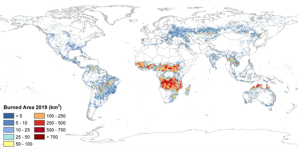
The current product is MODIS Fire_cci v5.1, and was released on November 2018, with subsequent extensions to include BA for the years 2018 to 2020. It was obtained combining spectral information from MODIS at 250m resolution and thermal information from the MODIS active fire products.
FireCCI51 is available for years 2001 to 2020 at two different resolutions:
- pixel (0.002246º - ~250m)
- grid (0.25°)
The previous version based on MODIS, FireCCI50 (version 5.0 of the algorithm) is still available, as well as previous versions based on MERIS data (FireCCI41 and FireCCI31) in the CCI repository to maintain the historical archive. It is not recommended to usethe previous versions of this product, as the latest (FireCCI51) has the longest time series, most improved algorithm, and best validation results.
For further information on the characteristics and variables of the dataset, please refer to the Product User Guide.
Please provide this information before downloading the product, to keep you up to date with new releases, and for statistical purposes: