Fire
Consortium

Fire_cci long-term Burned Area dataset
In this webpage, you will be able to download the long-term beta global burned area (BA) dataset generated by the Fire_cci project. Fire_cci is one of the Essential Climate Variables (Fire disturbance) under the European Space Agency’s Climate Change Initiative. The scope of the project is to provide long-term burned area information for global vegetation and atmospheric modellers.
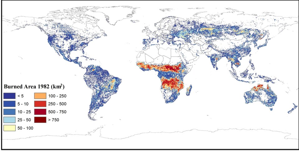
This product is based on AVHRR Land Long Term Data Record ( AVHRR-LTDR ) data, and it is called FireCCILT11 for short.
FireCCILT11 covers the period 1982-2018, with the exclusion of 1994 due to lack of sufficient input images. It is provided at two spatial resolutions:
- pixel (0.05º, the original LTDR resolution)
- grid (0.25°)
This version of the product replaces the FireCCILT10 BETA product, which has been deprecated, but is still available for archiving and transparency purposes. FireCCILT10 covered the period 1982-2017, with the exclusion of 1994. It was provided as a grid product with a resolution of 0.25 degrees.
The improved algorithm used to obtain FireCCILT11 solved many of the inconsistencies found in the beta FireCCILT10, allowing to obtain a more consistent result during the whole time series.
For further information on the characteristics and variables of the dataset, the input datasets, and the improvements compared to the previous product, please refer to the Product User Guide.
Please provide this information before downloading the product, to keep you up to date with new releases, and for statistical purposes: