|
|
|||||
|
|
|||||
|
Surveying and manual coordinate entry In surveying, measured angles and distances from known points are used to determine the position of other points Surveying field data are almost always recorded as
polar coordinates and transformed into rectangular coordinates. Polar
coordinates are composed of:
Global positioning systems (GPS) A Global Positioning System (GPS) is a set of hardware and software designed to determine accurate locations on the earth using signals received from selected satellites. Location data and associated attribute data can be transferred to mapping and Geographical Information Systems (GIS). GPS will collect individual points, lines and areas in any combination necessary for a mapping or GIS project. More importantly, with GPS you can create complex data dictionaries to accurately and efficiently collect attribute data. This makes GPS is a very effective tool for simultaneously collecting spatial and attribute data for use with GIS. GPS is also an effective tool for collecting control points for use in registering base maps when known points are not available. GPS operate by measuring the distances from multiple satellites orbiting the Earth to compute the x, y and z coordinates of the location of a GPS receiver. The following forms of GPS equipment are currently
available to users:
GPS can be used for georeferencing, positioning, navigation, and for time and frequency control. GPS is increasingly used as an input for Geographic Information Systems particularly for precise positioning of geospatial data and the collection of data in the field. The system hardware contains three parts; the antenna, the receiver, and the datalogger; sometimes called a data-collector. The datalogger is a hand-held computer that contains software to coordinate signal collection and storage, file manipulation, and file transfer to and from a computer. Some systems might combine some of these elements into a single piece of hardware. The system software, which normally resides on a computer, has four primary functions: preplanning, post-processing correction of the raw satellite data, display/editing of the data, and converting/exporting of the data. Preplanning includes determining satellite availability for a particular place and time, and the preparation of data dictionaries for a particular job. Correction involves the use of a base station file to apply corrections to the raw data collected from the satellites, greatly improving accuracy. Editing and display can include averaging points, connecting points to form lines or areas, smoothing, measuring distance and area, and displaying the data to screen. GPS software programs are not meant to be map-making programs and usually most of the final editing will take place in a GIS program. Data conversion and export include the capability to convert from the spherical Latitude/Longitude (Lat/Long) coordinates that the receiver collects into a variety of other coordinate systems and datums, and then exporting this data in a variety of formats used by different GIS programs.
The known distances and locations of each visible satellite are used to locate the position of the GPS receiver. We can place ourselves anywhere on a sphere around one satellite once we know the distance to the satellite. Known distances from two satellites will place us on a circle that is the intersection of two spheres. Known distances from three satellites will place us in two points, which is the intersection of three spheres. We may be able to eliminate one of these points as being impractical, such as out in space or deep underground. With one gone, the other must be correct. Three satellites are sufficient, at least theoretically, to provide receiver location. More satellites simply add confirmation to the receiver location. In practice, the more satellites the better. Four satellites are the minimum to secure only one, absolutely technically, trigonometrically unambiguous location. Three work in practice since we can eliminate the absurd location. Four satellites (normal navigation) can be used to determine three position dimensions and time. However user mistakes, including incorrect geodetic datum selection, can cause errors from 1 to hundreds of meters. Receiver errors from software or hardware failures can also cause errors of any size. GPS satellite signals are blocked by most materials. GPS signals will not mass through buildings, metal, mountains, or trees. Leaves and jungle canopy can attenuate GPS signals so that they become unusable. In locations where at least four satellite signals with good geometry cannot be tracked with sufficient accuracy, GPS is unusable. Planning software may indicate that a location will have good satellite coverage over a particular period, but terrain, building, or other obstructions may prevent tracking of the required satellites.
The GPS satellites circle the earth twice a day, 10,900 miles above the earth. There are 24 satellites in the GPS constellation. Twenty-one satellites can be called on at any time; the other three are spares in case one of the others becomes unhealthy. Five or six satellites are above and visible (by radio wave) to any spot on the earth at any one time. Buildings, hills, trees, and other ground features may block one or more at one time, or one or two of the satellites may not be at their best. These problems will reduce the number of useful satellites above a position to two, and maybe even one, but three or four are commonly available. Often as many as five and six are visible. The location in space of each satellite is known. The orbits are carefully planned and constantly updated so that actual location is never off by much from the intended location. Each satellite constantly announces its number, and the time that signal was sent. The distance from each satellite to the receiver is calculated by comparing the time the signal says it was sent with the time the receiver picks up the signal. The time difference is multiplied by the speed of light to get the distance from satellite to receiver. This is done for each satellite the receiver can "see". The US Government has just 'switched off' Selective Availability for public users of GPS. This means that the errors that were previously deliberately put into the GPS signals have now been removed and even small hand-held units can achieve an accuracy of about 10 metres in position.
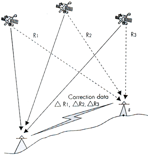
Differential GPS (DGPS) Techniques The idea behind all differential positioning is to correct bias errors at one location with measured bias errors at a known position. A reference receiver, or base station, computes corrections for each satellite signal for all satellites in view (see Figure 1). Differential GPS are measured at two stations, one of which has known coordinated. Correction values can then be used to calculate the exact position of the unknown points from the roving receiver. In this way it is possible to calculate the exact position of survey control stations on land or of mobile objects such as boats. The use of differential GPS helps users achieve better accuracy. |
|||
|
|
|||
|
|
|||
| Click here to download all theory presented in this module | |||
|
|
|||