|
|
|||||
|
|
|||||
|
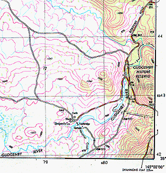
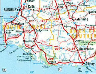
Map scale is the relationship existence between distance on a map and the corresponding distance on the earth. It is usually expressed in the following form: 1:10,000, meaning that 1 unit of measurement on the map represents 10,000 of the same units on the earth's surface. The scale ratio 1:100,000 means that one unit of distance on the map represents 100,000 of the same units of distance on the Earth. So on a 1:100,000 scale map, one cm on the map equals one km on the ground because one km has 100,000 cm. Because the scale ratio is a constant, it is true for whatever units in which the fraction is expressed. A 'large' scale map is one in which a given part of the Earth is represented by a large area on the map. Large scale maps generally show more detail than small scale maps because at a large scale there is more space on the map in which to show features. Large scale maps are typically used to show site plans, local areas, neighborhoods, towns etc. 1:2,500 is an example of a large scale. A 'small' scale map is one in which a given part of the Earth is represented by a small area on the map. Small scale maps generally show less detail than large scale maps, but cover large parts of the Earth. Maps with regional, national, and international extents typically have small scales, such as 1:1,000,000 (see Figure 2). Large scale maps typically show more detail than small scale maps, whereas on smaller scale maps there is simply not enough room to show all the available detail, so features such as streams and roads often have to be represented as single lines, and area features like cities, have to be shown as points. This is called generalization. The larger a scale is the smaller will be the number in the scale. For example, a 1:10,000-scale map is said to have a larger scale than a 1:100,000-scale map.
Map projections are a mathematical model for converting locations on the earth's surface from spherical to planar coordinates, allowing flat maps to depict three-dimensional features. Some map projections preserve the integrity of shape, others preserve accuracy of area, distance or direction. All map projections distort shape, area, distance or direction to some extent. On large scale maps, such as street maps, the distortion caused by the map projection being used may be negligible because your map will typically cover only a small part of the Earth's surface. On smaller scale maps, such as regional and world maps, where a small distance on the map may represent a considerable distance on the Earth, this distortion may have a bigger impact, especially if the application involves comparison of the shape, area or distance of different features. In these cases, knowledge of the characteristics of the map projection you are using becomes more important.
It is natural to equate detail with accuracy. However, when we talk about the level of detail on a map, we are referring to the quantity of geographic information shown. Map accuracy, on the other hand, is a statement of the quality of this information. While large scale maps typically show more detail than small scale maps, there is no standard rule for how many features a map of a given scale can show, and in how much detail. Instead, this is a cartographic decision depending on the purpose of the map and how many symbols can be drawn in the available space without visual clutter. On smaller scale maps there is simply not enough room to show all the available detail, so features such as streams and roads often have to be represented as single lines, and area features like cities, have to be shown as points. This is called generalisation. Compare Figure 1 and Figure 2. When features are generalised their level of detail is reduced to avoid cluttering the map, but their overall shape and position is retained. Therefore, a small scale map of a coastline will not show every cove that you might see on a large scale map. Smaller scale maps may also omit features completely. In some GIS packages spatial data can be generalized after it has been created. ARC/INFO has functions for automatically generalizing existing spatial data by removing coordinates.
The accuracy of a map is not dependent on the map's scale. Instead, it depends on the accuracy of the original data used to compile the map, how accurately this source data has been transferred onto the map, and the resolution at which the map is printed or displayed. The accuracy of the maps you create with ArcView depends primarily on the quality of the coordinate data in your spatial database. To create the spatial data, existing maps or manuscripts may have been digitized or scanned, and other original data, such as survey reports, aerial photographs and images, and data from third parties may also have been used. Your final map will therefore reflect the accuracy of these original sources. As scales become smaller, one unit of map distance represents a larger distance on the ground. So if one of the features shown on a very small scale map is out of line by just a part of a millimeter, it would still represent a substantial inaccuracy in reality.
Map resolution is defined as:
|
||||||
| Click here to download all theory presented in this module | ||||||
|