Introduction
As part of the present project we are coordinating a methodology which acts as support to the sustainable territorial planning of the future development of metropolitan spaces. This methodology covers jointly and integrally different key aspects impinging on this phenomenon. Thus, in the first place it is necessary to gain in-depth knowledge of the trends, implications, features, etc. of the growth experienced by metropolitan spaces by means of the detailed study of recorded socioeconomic and territorial changes and of the impact of different instruments of territorial planning on urban development. Working from these premises it is possible to reproduce future scenarios offering information about the consequences of this evolving phenomenon for the territory. To this end, a combination of predictive and prescriptive simulation models is used which, unlike other proposals to date, make available to us valuable information about what might happen if the phenomenon continued in line with current trends, and also about what outcomes would be desirable in terms of principles of sustainability, justice and spatial efficiency. In this last respect, the proposal would culminate in the development of a procedure enabling us to diagnose the sustainability and environmental costs of the effects of the urban development (based on the calculation of Total Territorial Value) of both the current situation and the simulated future scenarios. This method is applied to two metropolitan spaces (Madrid and Granada) which differ in terms of dimension and temporal period of formation. In short, our research aims to provide administrations with methodologies which may help to formulate better informed and more sustainable proposals regarding territorial organisation, thus permitting the more balanced and cohesive development of those areas which are strongly influenced by the spread of large metropolitan spaces. Four research teams take part in this Project from four different universities: the University of Alcalá (Project Coordinators); the National Distance Learning University; the University of Granada; and the Rey Juan Carlos University. The Observing Promoting Bodies who stated their support for the project and their interest in the results as potential users of them were: the Town Hall of Granada (through the Municipal Agenda 21 Office); the Spanish Sustainability Observatory; the Land Management & Natural Hazards unit of the Institute for Environment and Sustainability (DG Joint Research Centre, European Commission); the National Geographic Institute; the Madrid “Sierra Oeste” Consortium; and the Consortium of Madrid’s University City. The following figure (figure 1) shows the project’s GOALS.
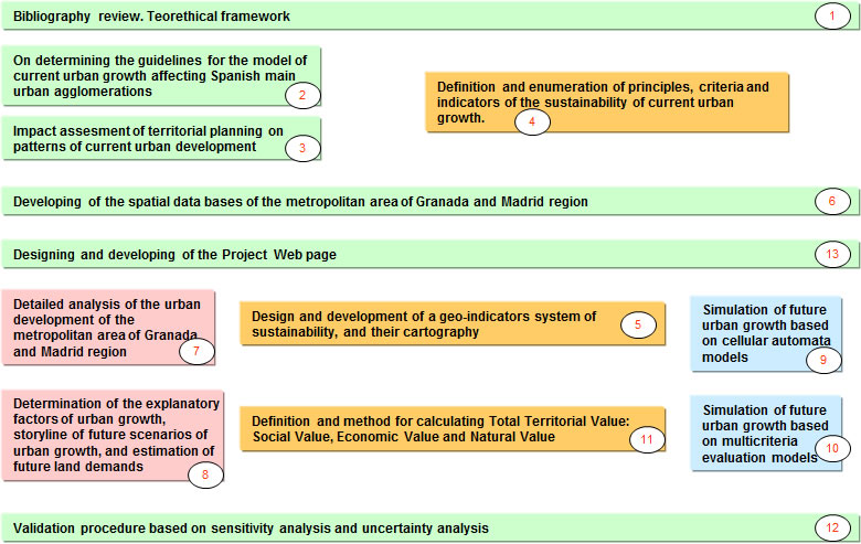
Figure 1. Project goals

It is followed by a brief summary of the activities carried out and the results achieved to date following the numbers which appear in the figure:
2. On determining the guidelines for the model of current urban growth affecting Spain’s main urban agglomerations ( ). ).
3. Impact assessment of territorial planning on patterns of current urban development ().
4 and 5. Definition and enumeration of principles, criteria and indicators of the sustainability of current urban growth. Design and development of a geo-indicators system of sustainability, and their cartography ().
6. Developing of the spatial data bases of the metropolitan area of Granada and Madrid region ().
7. Detailed analysis of the urban development of the metropolitan area of Granada and Madrid region ().
8. Determination of the explanatory factors of urban growth, storyline of future scenarios of urban growth, and estimation of future land demands ().
9. Simulation of future urban growth based on cellular automata models ().
10. Simulation of future urban growth based on multicriteria evaluation models ().
11. Definition and method for calculating Total territorial Value: Social Value, Economic Value and Natural Value ().
12. Validation procedure based on sensitivity analysis and uncertainty analyisis ().
13. Designing and developing of the project web page ().
|