|
|
|||||
| |

|
|
|||||||||||||||||||||||||||||||
| raster based GIS | |||||||||||||||||||||||||||||||
|
raster representation of data |
|||||||||||||||||||||||||||||||
|
|
|||||||||||||||||||||||||||||||
|
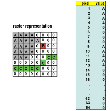
Raster is a method for the storage, processing and display of spatial data. Each area is divided into rows and columns, which form a regular grid structure. Each cell must be rectangular in shape, but not necessarily square. Each cell within this matrix contains location co-ordinates as well as an attribute value. The spatial location of each cell is implicitly contained within the ordering of the matrix, unlike a vector structure which stores topology explicitly. Areas containing the same attribute value are recognised as such, however, raster structures cannot identify the boundaries of such areas as polygons. Raster data is an abstraction of the real world where spatial data is expressed as a matrix of cells or pixels (see figure 9), with spatial position implicit in the ordering of the pixels. With the raster data model, spatial data is not continuous but divided into discrete units. This makes raster data particularly suitable for certain types of spatial operation, for example overlays or area calculations. Raster structures may lead to increased storage in certain situations, since they store each cell in the matrix regardless of whether it is a feature or simply 'empty' space.
|
|||||||||||||||||||||||||||||||
|
|
|||||||||||||||||||||||||||||||
|
A pixel is the contraction of the words picture element. Commonly used in remote sensing to describe each unit in an image. In raster GIS the pixel equivalent is usually referred to as a cell element or grid cell. Pixel/cell refers to the smallest unit of information available in an image or raster map. This is the smallest element of a display device that can be independently assigned attributes such as colour. Pixel size and number of rows and columns: |
|||||||||||||||||||||||||||||||
|
|
|||||||||||||||||||||||||||||||
| raster
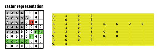
data structures exhaustive enumeration (figure 9) In this data structure every pixel is given a single value, hence there is no compression when many like values are encountered. run-length
encoding (figure 10) |
|||||||||||||||||||||||||||||||
|
|
|||||||||||||||||||||||||||||||
|
|||||||||||||||||||||||||||||||
|
|
|||||||||||||||||||||||||||||||
|
|
|||||||||||||||||||||||||||||||
|
|
|||||||||||||||||||||||||||||||
|
|
|||||||||||||||||||||||||||||||
| advantages/disadvantages of raster and vector data models | |||||||||||||||||||||||||||||||
|
|||||||||||||||||||||||||||||||
|
|
|||||||||||||||||||||||||||||||
| data capture | |||||||||||||||||||||||||||||||
| see the Spatial Data Entry module for more information on this | |||||||||||||||||||||||||||||||
|
|
|||||||||||||||||||||||||||||||
| |
Remote Sensing | ||||||||||||||||||||||||||||||
| |
Manual
digitisation
|
||||||||||||||||||||||||||||||
| Automatic digitisation | |||||||||||||||||||||||||||||||
| Scanning | |||||||||||||||||||||||||||||||
|
|
Rasterisation of vector data | ||||||||||||||||||||||||||||||
|
|
|||||||||||||||||||||||||||||||
|
The process of converting vector data, which is a series of points, lines and polygons, into raster data, which is a series of cells each with a discrete value. This process is essentially easier than the reverse process, which is converting data from raster format to vector format. raster
to vector conversion |
|||||||||||||||||||||||||||||||
|
|
|||||||||||||||||||||||||||||||
|
See the raster
spatial analysis module for information on raster data analysis.
|
|||||||||||||||||||||||||||||||
|
Click here
to download all theory presented in this module
|
|||||||||||||||||||||||||||||||