|
|
|||||
| |

|
|
introduction |
||||||||||||
| raster based GIS | |||||||||||||
| vector based GIS | |||||||||||||
|
|
|||||||||||||
|
Like the field of geography, the term Geographic Information System (GIS) is hard to define. It represents the integration of many subject areas. Accordingly there us no absolutely agreed upon definition of a GIS (deMers, 1997). A broadly accepted definition of GIS is the one provided by the National Centre of Geographic Information and Analysis:
Geographic information systems have emerged in the last decade as an essential tool for urban and resource planning and management. Their capacity to store, retrieve, analyse, model and map large areas with huge volumes of spatial data has led to an extraordinary proliferation of applications. Geographic information systems are now used for land use planning, utilities management, ecosystems modelling, landscape assessment and planning, transportation and infrastructure planning, market analysis, visual impact analysis, facilities management, tax assessment, real estate analysis and many other applications. Functions of GIS include: |
|||||||||||||
|
|
|||||||||||||
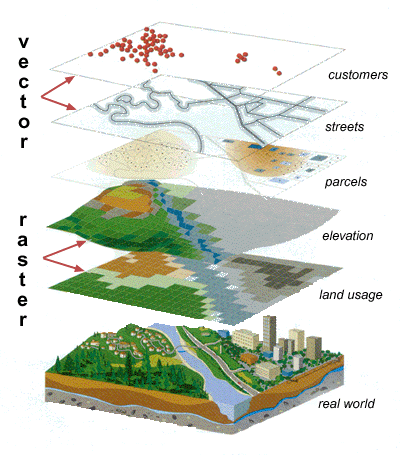
| A more comprehensive
and easy way to define GIS is the one that looks at the disposition, in
layers (Figure 1), of its data sets. "Group of maps
of the same portion of the territory, where a given location has the same
coordinates in all the maps included in the system". This way, it is possible
to analyse its thematic and spatial characteristics to obtain a better
knowledge of this zone.
|
|||||||||||||
|
|
|||||||||||||
|
|
|||||||||||||
|
|
|||||||||||||
|
mapping
locations mapping
quantities mapping
densities finding
distances mapping
and monitoring change
|
|||||||||||||
|
|
|||||||||||||
|
|
|||||||||||||
|
geospatial
data Conceptually, geographic data can be broken up
in two elements: Spatial component: The observations have two aspects in its localisation: absolute localisation based in a coordinates system and topological relationship referred to other observations. Example: The Department of Geomatics is located at the particular coordinate X,Y, or, The Department is located between Grattan Street and Old Engineering Building. A GIS is able to manage both while computer assisted cartography packages only manage the absolute one. Thematic component: The variables or attributes can be studied considering the thematic aspect (statistics), the locational aspect (spatial analysis) or both (GIS). |
|||||||||||||
|
|
|||||||||||||
|
|
|||||||||||||
|
data for GIS applications includes: |
|||||||||||||
| see the Spatial Data Entry module for more information on this | |||||||||||||
|
|
|||||||||||||
|
|
|||||||||||||
|
|
|||||||||||||
|
Click
here to download all theory presented in
this module
|
|||||||||||||